Showing posts with label poll maps. Show all posts

Wednesday, January 11, 2012

Saint-Maurice--Champlain and the Liberals (poll maps)

2011 poll map of Saint-Maurice--Champlain coloured by leading party.
Yesterday, it was announced that NDP MP Lise St-Denis crossed the floor to join the Liberal Party of Canada. Apparently, she had a falling out with the party, as she disagreed with the party on some issues. It was enough for her to switch, anyways.

As an electoral geographer, I wanted to take a look at the maps, to see if this was a good idea for her. And what I found was a resounding "no". Historically, this riding has gone Liberal before. After all, part of it was represented by Jean Chretien when he was Prime Minister. However, it should be noted that many of his elections were a little too close for comfort, and without him on the ballot, the area would assuredly have gone to the Bloc. This riding was created in 2003 from the previous riding of Saint-Maurice, which Chretien represented and Champlain, which voted for the BQ in 1993, 1997 and in 2000. The Liberals came within 15 votes of winning Champlain in 2000.  Only the Shawinigan area was taken from the riding of Saint-Maurice. Geographically, most of the riding came from Champlain. Population wise however, 60% of the riding's inhabitants previously lived in Saint-Maurice.

Liberal vote by poll (2011)


The BQ won Saint-Maurice--Champlain in 2004, 2006 and in 2008 before losing to the NDP in 2011. The Liberals have gotten worse and worse in this riding over time. The Liberals finished 2nd in the riding in 2004, with 31% of the vote. They slipped to 3rd in 2006 and 2008 where they received 12% and 21% of the vote respectively. In 2011, they slipped further back to 4th, getting 12% once again.

Mme. St-Denis has cancer, and will probably not run for re-election in 2015. If she followed the NDP's party policy of resigning before switching parties, she would have had to run in a by-election. Under the current political climate, this seat would be a race between the NDP and the BQ. The Liberals would be lucky to finish 3rd. St-Denis, who doesn't live in the riding has no connections there, and refused to move there upon getting election. It is unlikely that her incumbency status would help her win at all.

In 2011, the Liberals won just three regular polls in the entire riding. They won two in the Town of La Tuque, and one apartment poll in Shawinigan. The Liberals did the best in the La Tuque municipality, where their candidate was the former Chief Administrative Officer. The Municipality of La Tuque covers a large geographical area; most of the riding is actually located within the municipality. One would expect the Liberals to have done quite well in Shawinigan, the hometown of Jean Chretien; but they did not.

The NDP did well right across the riding, winning most polls. The Bloc won a small number polls. They won a few clusters here and there, while the Tories won no polls, despite winning more votes than the Liberals.

Map of the riding; highlighted to show former riding boundary between Champlain and Saint-Maurice and also showing the boundary of the municipality of La Tuque.

Tuesday, July 26, 2011

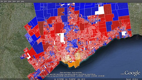
2011 federal election poll maps: Toronto (part 3)

Click to enlarge.  Map credit: Shilly
Continuing with of my 4 part series analyzing Toronto's poll map from the 2011 federal election. (see part 1 and part 2)

Part 3 will wrap up my analysis of Toronto's riding. Part 4 (which will be on a later day) will look at some demographic maps of the city to compare with the poll maps.

Toronto Centre
The only break in the NDP's sweep of Toronto's lakefront was in Toronto Centre. Demographically, the riding is very diverse. It consists of Toronto's gay friendly Church and Wellesley area, it contains Canada's most dense neighbourhood in St. James Town- which is also very poor. It also includes the very affluent Rosedale neighbourhood in the north of the riding and part of Toronto's Bay Street financial district.

Liberal MP Bob Rae was the winner here in 2011, earning 41% of the vote. He lost a lot of support though from his 54% showing in 2008, which included an 18,000 vote lead over the Conservative candidate. However in 2011, it was the NDP that finished 2nd, coming within 6,000 votes of Rae. Despite Rae's somewhat comfortable margin, he actually won less polls than the NDP candidate. The NDP's strength in the south of the riding and dismal performance in the affluent north was contrasted by the opposite for the Conservatives. The Liberal vote was more spread out however, meaning strong seconds across the riding gave Rae the victory.

In 2008, the Liberals nearly swept the riding in their support. They lost just six polls. 5 to the Tories in affluent areas such as Rosedale and Yorkville, and one to the NDP. However, 2011 was much different. As mentioned, Liberal support was more spread out across the riding. They won much of their poll in the middle of the riding, separating the Conservative north and NDP south. Their best neighbourhoods were in Summerhill, Cabbagetown, Downtown and the southern part of Rosedale. Cabbagetown and Regent Park, to its south were the Liberal's best neighbourhoods in 2008. However, Regent Park, Canada's first social housing neighbourhood, swung heavily to the NDP in 2011.The NDP won much of the south of the riding, including Regent Park, the Garden District, Church & Wellesley, St. James Town and St. Lawrence. All areas picked off from the Liberals. The Tories meanwhile expanded their support in the affluent neighbourhoods in the north of the riding, like Rosedale, Moore Park and Yorkville. Again, all at the expense of the Liberals.

Toronto--Danforth
This is NDP leader Jack Layton's riding. Jack won every single poll in 2011, and won nearly every poll in 2008. He won over 60% of the vote in 2011, up from 45% in 2008. This mostly meant cementing soft NDP polls into stronger polls. Layton's best neighbourhood in both elections was the working class Leslieville area, where he won a majority of votes in almost every poll. The NDP's worst polls were in Riverdale, Greektown and Old East York, which were the only neighbourhoods with polls where they won less than 50% of the vote. These were also the only areas where the Liberals won polls in 2008.

Trinity--Spadina
Trinity--Spadina is the riding of Layton's wife Olivia Chow. Chow won 54% of the vote in 2011, and won all but four polls in the far northeast of the riding. The 2008 race was much closer between her and her Liberal opponent, which she only beat by 3,500 votes. Before the "orange wave", some pundits predicted the increase in condo development in the riding would make this riding a Liberal pickup.  However, Chow beat the same Liberal, Christine Innes by over 20,000 votes in 2011- a swing of 12.5% from the Liberals to NDP.

In 2008, the NDP won most of the poll in the riding, but most with less than 40% of the vote. The Liberals won polls scattered across the riding, with a cluster in the northeast corner of the riding, which is known as "The Annex", a relatively affluent and educated neighbourhood. The Tories also won one poll in The Annex, and two polls on the Harbourfront. The NDP's best neighbourhood was the multicultural Kensington Market area.

In 2011, the NDP won a majority of the vote in most of the polls, with their best area being the Kensington Market again, and neighbouring Chinatown (Chow is Chinese). The Liberals won three polls in the Annex, and the Tories held on to their one poll there, but lost their Harbourfront polls.

Willowdale
One of the many Tory pickups from the Liberals was in the riding of Willowdale. Liberal MP Martha Hall Findlay lost by just 1,000 votes to the Conservative candidate, Chungsen Leung. She had beaten the Conservative candidate by 8,000 votes in 2008.

Willowdale is fairly homogenous in its voting patterns. Hall Findlay's victory in 2008 allowed her to win most of the polls. The closeness of the 2011 race meant that both the Tories and Liberals won polls across the riding. The Conservatives' best neighbourhood in both 2008 and 2011 was in the north end of the Bayview Woods-Steeles. This is where they won 5 polls in 2008.  The Tories also did well in Hillcrest Village, Newtonbrook, and the eastern half of the Willowdale neighbourhood in 2011. The Liberals won the western half of Willowdale and Bayview Village. Other neighbourhoods were more mixed. The NDP won one poll, the one containing Seneca College.

York Centre
The same result occurred in neighbouring York Centre, which the Tories also picked up, on a similar 10.3% swing from the Liberals. Liberal MP Ken Dryden went down to defeat, losing by over 6,000 votes to Conservative Mark Adler. The Conservatives had targeted this riding, having only lost it by 2,000 votes in 2008.

Unlike Willowdale, York Centre is much more polarized politically. The riding is separated in two parts thanks to the Downsview Airport which is right in the middle of the riding. The eastern portion, which has more people, voted heavily Conservative, while the smaller western portion voted heavily Liberal. Dryden was able to win in 2008 by winning parts of the eastern part of the riding, while winning every poll in the west.

The western part of the riding is called Downsview, and has large Black, Italian and Latin American populations. The Tories made inroads here in 2011, by winning a handful of polls. The eastern part of the riding is divided up into many smaller neighbourhoods- all of which voted heavily Tory. In 2008, the Tories only won Armour Heights and the Westminster-Branson neighbourhoods. The Tories have been making inroads among the high Jewish population in this riding, which allowed them to pick up Bathurst Manor and hold onto Westminster-Branson. They also won the neighbourhood of Wilson Heights.

York South--Weston 
York South--Weston is an old NDP seat, held federally by former leader David Lewis in the 1960s and 1970s, and by the provincial CCF/NDP for most of the period between 1943 and 1996. However, it has been a fairly safe Liberal seat ever since. In recent years, the NDP has been targeting the party once again, acquiring it provincially in a by-election in 2007- only to lose it in the general election later in the year. So, when the orange wave came to town in 2011, it only made sense for this riding to be swept up from the Liberals to the NDP.

2011 faced a rematch between NDP candidate Mike Sullivan and Liberal MP Alan Tonks. Tonks defeated Sullivan in 2008 by over 6,000 votes. However, Sullivan won by less than 3,000 votes in 2011, benefiting from a 13% swing from the Liberals to the NDP.

In 2008, the Liberals won most of the polls in the riding, but the NDP had concentrated support in the southern half of the Weston neighbourhood, and in the diverse Mount Dennis neighbourhood. Liberal support was strongest in the northeast part of the riding, roughly northeast of Black Creek. When the tides turned in 2011, it was this part of the riding (the Maple Leaf and Amesbury neighbourhoods) that stuck with the Liberals.  The NDP strengthened their support in Weston, but also in the south part of the riding where they were nearly shutout in 2011. They also made inroads in the area between the CN Railway and Black Creek. The Tories won six polls in 2011, having been shutout in 2008.

York West
Perhaps one of the safest Liberal seats in the country now is York West. The Liberals have held this seat in 1962. York West is one of the poorest ridings in the country, and is home to the infamous "Jane and Finch" area.

York West's MP, Judy Sgro won this seat by over 5,000 votes, which is a considerable amount considering the low turnout in this riding. Sgro won by nearly 12,000 votes in 2008 and was able to win all but one poll in the riding. The NDP won that poll, which is located at York University. In 2011, the NDP expanded on this one poll by winning the whole York University area, and a handful of polls in other parts of the riding. The Tories were also able to win three polls of their own. The Liberals however still won most of the polls in the riding. Their best neighbourhood was Humber Summit in the northwest corner of the riding, an area with a high Italian and South Asian population.


Stay tuned for part 4!

Wednesday, July 20, 2011

2011 federal election poll maps: Toronto (part 1)

Click to enlarge
If you've been following my twitter feed (which I just added to the site), you will know that last night, Shilly, a member of the US Election Atlas Forum released the poll by poll map of the entire city of Toronto from the May 2011 election. He has given me permission to re-post his map here, which I cannot thank him enough for, as it is drool-worthy for anyone who is as obsessed with Canadian election maps as I.

But now is the hard for me. Trying to make sense of this map. Compared to 2008, the map is much more blue and orange, and less red. The Conservatives picked up 9 ridings in the city in 2011, after having won none in 2008. The NDP picked up 6 ridings in the city. All 15 of these seats came at the expense of the Liberals. The Liberals were relegated to certain immigrant communities heavily concentrated in the northwest part of the city and in parts of Scarborough. The NDP expanded on their traditional lakefront ridings, by nearly sweeping the region, and also picked up the riding of Scarborough--Rouge River which has a high Tamil population. The Tories won in more upper class regions and in Scarborough.

Riding by riding analysis
Map of the ridings in Toronto. It's missing Pickering--Scarborough East (on the east side of the map) which was included in Shilly's map.

Beaches--East York
This riding was held by the Liberals, but the NDP picked it up on a swing of 9.9%. While the riding is a safe NDP riding provincially, federally it has been allusive for the party, having failed to win it in 2008 when they ran a star candidate in former MPP Marilyn Churley (who had represented neighbouring Toronto--Danforth). The NDP won the riding even with a lesser known candidate in Matthew Kellway, who won by over 5000 votes.

The NDP won most of the polls in the riding, but saw their highest percentages in the central part of the district, between Kingston Rd and Cosburn Ave (Woodbine Heights and Upper Beaches). This region was their strength in 2008 as well, even though the Liberals still won more polls there. The Liberal vote was spread around the riding more, picking up a few polls in the far north and south of the riding. Their strongest poll was in the highly multicultural neighbourhood of Crescent Town. The Conservatives won at least 12 more polls than their previous one poll in 2008. They won all but one poll in the fairly wealthy Parkview Hills neighbourhood, a few polls in Woodbine Gardens, and won four lakefront polls in the southwest corner of the riding.

Davenport
Davenport is another riding the NDP picked up from the Liberals. The riding has been targeted by the NDP in recent years, but 2011 marks the first time it has ever voted NDP on the federal level. The area has a large Portuguese population, and in recent years has seen in influx of young adults moving into the riding. The NDP ran an excellent campaign in the riding, running star candidate and former punk rocker Andrew Cash.  The NDP gained the seat with a huge 20.2% swing from the Liberals, defeating incumbent Mario Silva.

Politically, Davenport is polarized between north and south divided by the CP Railway. The north is where there Liberal support is the strongest, while the south is where the NDP support is strongest. In 2008, the Liberals won the south part of the riding, but it was the only part of the riding where the NDP won polls. In 2011, the reverse happened, where the Liberals not only did not win a poll south of the CP Railway, they did not win any polls south of St. Clair Ave. Liberal polls were concentrated in the heavily Italian and Portuguese neighbourhoods of Fairbank and Earlscourt. The further south in the riding, the more NDP it is, with the party making inroads into Little Portugal. The strongest neighbourhood for the party was Dufferin Grove, which is a working class neighbourhood. This neighbourhood in particular has a lot of young adults living in it.

Don Valley East
Don Valley East was a surprise pick up by the Tories in 2011. The lost the 2008 election by roughly 6,500 votes. However, Conservative candidate Joe Daniel was able to overcome this deficit by defeating the Liberal MP, Yasmin Ratansi by less than 900 votes. The NDP did fairly well in this riding, getting 25% of the vote here. 

In 2008, the Liberal vote was spread fairly evenly across the riding, winning most of the polls. Tory support was concentrated around the Donalda Golf & Country Club, and parts of the Parkwoods and Victoria Park Village. In 2011, the Conservative expanded their support in these neighbourhoods, sweeping most polls there. They also made inroads north of the 401, where they won just 2 polls in 2008. They won most of the polls in the neighbourhood of Henry Farm, and did very well in Don Valley Village and Pleasant View.

Liberal support was more concentrated in 2008. They were relegated mostly to the area north of Van Horne Ave. in the Don Valley Village, they won a handful of polls in Pleasant View, and continued to win most of the polls south of Eglinton Ave, in the far south of the riding - which is where their best poll was.

The NDP, which did not win a single poll in 2008, picked up quite a few in 2011. NDP polls were concentrated in 5 areas: on the north side of Eglinton Ave, a few polls in the Don Mills area, along York Mills Rd., the eastern part of Henry Farm, and around the "peanut" in Don Mills Village.

Don Valley West
Don Valley West was another Conservative pick up from the Liberals. The riding is very polarized between the two parties. Both the 2008 and 2011 elections were fairly close. Liberal MP Rob Oliphant won in 2008 by less than 3000 votes to the Conservative John Carmichael. They had a rematch in 2011, where Carmichael edged out Oliphant by 600 votes.

In 2008, the Conservative vote strength is concentrated in the wealthy York Mills, Bridle Path and Lawrence Park neighbourhoods. Liberal support was concentrated in Bedford Park, North Toronto, Don Mills, and Flemingdon Park. The neighbourhood of Leaside was mixed between the two parties. The densely populated working class neighbourhood of Thorncliffe Park was won by the Liberals, but the NDP also won many polls.

In 2011, the Tories made inroads in many of these Liberal communities. They won over the neighbourhood of Leaside, nearly swept Don Mills and made gains in Bedford Park and North Toronto. Liberal support held firm in the south end of the riding in Flemingdon Park an Thorncliffe Park where they gained all of the NDP polls (the NDP candidate was noticeably absent during the campaign). The NDP won one poll in 2008, at the corner of Bayview and the 401- which I believe is an apartment building.

Eglinton-Lawrence
Eglinton-Lawrence was one of the top 2 targets for the Tories in the city. They had only lost by 2,000 votes in 2008. In a rematch between the Liberal MP, Joe Volpe and the Conservative candidate, Joe Oliver, the Tories picked up the seat, winning by 4,000 votes.

When you look at the map poll by poll map of the riding, you can easily see how polarized it is. Nearly everything west of Allen Rd. was won by the  the Liberals, and everything east by the Tories. This is not completely true of course, as the area east of Avenue Rd. was very good for the Liberals as well (south of Lawrence).

In comparing the 2008 and 2011 maps, one change in this riding is glaringly evident. It seems almost all of the polls in the neighbourhood of Lawrence Manor went from Liberal to Conservative. This neighbourhood has a large Jewish population. Jews in the Greater Toronto Area have switched their votes en masse it seems in recent years from the Liberals to the Conservatives. I'm actually surprised that this switch didn't happen earlier in Lawrence Manor.

The NDP won just three polls in the riding.


Etobicoke Centre
Etobicoke Centre was the third closest riding in all of Canada. 26 votes separated the Conservative victor, Ted Opitz and the Liberal incumbent, Borys Wrzesnewskyj. The Tories won the seat, benefiting from a 5.7% swing from the Liberals. The Liberals had won the seat in 2008 by 5,700 votes.

In 2008, the Conservative support was strongest in the area of the riding east of Kipling and south of Eglinton. Liberal support was strongest north of Eglinton and west of the 427 and south of Rathburn Rd. The same can be said about the 2011 election, except that the Tories encroached on these Liberal areas.

In 2011, the Tories won all the polls between Kipling and Royal York Rd, south of Eglinton. This area includes the exclusive St. George's Golf & Country Club, and is fairly wealthy. The Tories also did well in the wealthy Humber Valley Village, and in Eringate (where they won 4 polls in 2008). The Liberals remained dominant north of Eglinton, where they won most of the polls. West of the 427 and south of Rathburn remained mostly Liberal, but the Tories made inroads there. Islington, in the central part of the riding went from a mostly Liberal area to a mostly Conservative area. The NDP won 4 polls in the riding, 3 of which were in the Mall area, along the 427.

Etobicoke--Lakeshore
Etobicoke--Lakeshore was the riding that Liberal leader Michael Ignatieff was defending. As the Liberals began struggling, the media started to speculate that hey may lose his seat. That indeed did occur. The Conservative candidate, Bernard Trotties won the seat by nearly 3,000 votes on an 8.3% swing from the Liberals.

Ignatieff won by nearly 6,000 votes in 2008, and nearly swept the riding. The Tories only won a handful of polls- mostly in the southwest part of the riding and in The Kingsway, an affluent neighbourhood in the northeast of the riding. The tables turned in 2011 however, where the Tories nearly swept the riding.

Party support is clearly distributed fairly evenly in the riding. In 2011, the Tories strength was pretty even across the district. South of the GO Train was their worst area, where the Liberals and NDP won many polls. The NDP and Liberals did very well in New Toronto, and the Liberals did well in Mimico. The Tories still did well in the area however, winning in Long Branch and in parts of Mimico.

Etobicoke North
Finally, we get to a riding where the Liberals were actually able to keep. The Liberals have held this working class riding since 1988. Liberal MP Kirsty Duncan won the seat by over 3,000 votes. A much closer margin than her 2008 victory of nearly 6,000 votes. In terms of poll strength, Duncan nearly swept the riding in 2008, with the Tories and NDP only winning a few.

In 2011, the Tories made some significant inroads in the riding, winning most of the polls south of the Humber River West. North of the river is the poorer community of Rexdale, which makes up the majority of the riding. Rexdale was nearly swept by the Liberals, enabling them to hold the seat. The NDP, which has held the seat provincially in the past won just 5 polls, 3 of which were in the Rexdale Mall area in the south end of the riding.

And that is all for now. I will analyze the other ridings in future posts..

Monday, July 18, 2011

2011 federal election poll maps: Nipissing--Timiskaming

The second riding I will profile since Elections Canada released the 2011 election poll by poll results is Nipissing--Timiskaming. This riding is located in Northeastern Ontario, and is largely centred on the City of North Bay. The riding extends as far north as the Municipality of Temiskaming Shores in the north which incorporates the communities of Haileybury and New Liskeard. The riding runs along the Quebec border past Mattawa, Ontario, and then south into Algonquin Park. The riding goes west to also include the communities of Powassan and Trout Creek.

Click on map to enlarge
Nipissing--Timiskaming was the second closest race of the 2011 election. It required a judicial recount to determine that the Conservative candidate, Jay Aspin had defeated the incumbent Liberal MP, Anthony Rota by just 18 votes. The riding, which for the most part is a descendant from the old Nipissing riding has been solidly Liberal since 1988. In fact, it had only voted Tory once since 1921. Provincially, the area is more of a bellwether, in that it has switched parties often. Nipissing was the riding of former provincial Premier Mike Harris.

While the Tories picking up the riding was seen as a surprise by many, it wasn't that far fetched. Rota had defeated his Conservative opponent by less than 5000 votes in the 2008 election. A 6.2% swing from the Liberals to the Conservatives gave the Tories the narrow victory.

The Tories won the seat by picking up polls across the rural parts of the riding from the Liberals. They also made inroads into North Bay, however the Liberals still won the city overwhelmingly. The Conservatives saw their strongest performance in the Anglo Protestant areas just south of Lake Nipissing, which includes the Township of Nipissing, and the communities of Trout Creek and Powassan. The Liberals' strongest areas were in North Bay, and mostly in the north end of the city, which has a high francophone population.

While the Conservatives gained 4.4% at the polls, the NDP increased their vote even more, going up 5% points. They won a few polls scattered across the riding. Four of these polls were won in the rural heavily francophone townships of East Ferris and Bonfield. While the NDP candidate didn't have a French name, the NDP surge in Quebec probably helped the party in the French communities of the riding. The best NDP poll was the Bear Island Indian Reserve. While the reserve is small, the poll is quite large, and is that large dark orange area on the west side of the riding.

The Liberals have traditionally done well among the French in this riding, but this has slipped in 2011. While the Liberals won in the French parts of North Bay, the lost in the french rural areas and towns, like in Mattawa, and Temiskaming Shores.

Poll map note: While the 2011 poll by poll shape files are available, I used the 2008 boundaries here. I don't have a working GIS program, so I have to trace over the 2008 poll maps at the Smufmatic website. That would also explain a slightly wonky projection in my map.

Thursday, July 14, 2011

2011 federal election poll maps: Ottawa South

Last week, Elections Canada released the official poll by poll results of the 2011 federal election. The current format is either in PDF or CSV, while the Official Voting Results document they usually publish will not be available until August. Members of the US Election Atlas Forum (myself included) have begun to post riding maps already, and we can expect more to come. Some of the members have allowed me to use their maps, and I will post them in the future. But, I plan on doing an analysis of each map, so I will post them on the blog individually in the future.

Today, I will start with Ottawa South. This is the riding where I grew up, so I get to start with it.

Liberal MP David McGuinty won the seat with 44.0% of the vote, down 5.9% from 2008, and his lowest showing since his first election in 2004. The Conservative candidate, Elie Salibi was down just 0.01% to 33.3% from his mark set when he ran in the previous election. The NDP candidate, James McLaren received 18.2% of the vote, the highest ever for the party in the riding. He increased the NDP's share of the vote by 9.7%.

These results translated into a swing of 2.9% from the Liberals to the Tories, which helped them pick up a number of polls. The Tories won most of their polls in the south of the riding, mostly in Blossom Park. They also made inroads in the Urbandale community where they won 4 polls and tied in one more.  The Liberals won the overwhelming number of polls however, getting their best results in the central part of the riding, concentrated in the middle class Alta Vista area where they were able to win a majority of votes in most of the polls. The Liberals did bleed to the NDP in many of the immigrant areas, which one a handful of polls- for the first time since winning one in 2004. The NDP won six polls, and tied in two others. Two of these polls were in the working class Heron Gate area. The other polls were all apartment or town house polls. The Tories also won some similar apartment polls, where they benefited from vote splitting between the Liberals and NDP- and perhaps a "small c" conservative immigrant vote.