Showing posts with label 2008. Show all posts

Monday, November 17, 2014

Federal by-elections in Yellowhead and Whitby-Oshawa today

There's snow on the ground in Ottawa, and in many other parts of the country, which means the end of a very busy Fall election season is almost upon us. Today is especially busy with a provincial by-election in Saint John East, New Brunswick (covered in my previous post) and two federal by-elections, one in Yellowhead, Alberta and the other in Whitby—Oshawa in Ontario. There is just a couple of provincial by-elections in Newfoundland next week, and then there shouldn't be any more electoral events until the new year. I usually cover each riding separately when doing riding profiles for federal by-elections, but this time, I'm including both Yellowhead and Whitby—Oshawa in one post.


Whitby—Oshawa

Map of Whitby-Oshawa's neighbourhoods


The more interesting of the two federal by-elections today will be in the riding of Whitby—Oshawa. The riding became vacant in April under unfortunate circumstances when its MP, former Finance Minister Jim Flaherty, a Conservative, passed away after suffering a heart attack. The riding could have been included in the by-elections held on June 30, but was delayed by the Prime Minster, perhaps out of respect for the departed.

Whitby—Oshawa is a sprawling, suburban riding, located east of Toronto in the politically infamous “905” belt, that circles the city. The riding contains the entirety of the Town of Whitby, and the northwest and rural northern part of the city of Oshawa. The riding is mostly suburban in nature, but contains a large rural area in the north, which is separated by the urbanized south by woods and conservation areas. Within this rural area is the bedroom community of Brooklin, which is geographically separated from the rest of Whitby by a wooded area and farm land.


Demographics


Whitby—Oshawa is one of the faster growing ridings in Ontario, due to its suburban nature and proximity to Toronto. About half of all homes in the riding were built since 1990. With nearly 150,000 people, it is the 11th most populous riding in the province. The riding is 81% White, but is home to large Black and South Asian populations. Most of the White population is of British Isles descent, that is English, Irish and Scottish. Most of the population (83%) has English as its mother tongue, with French next at just 2%. 71% of the riding is Christian, with less than half of that number being Catholic. United Church and Anglicans make up the largest Protestant denominations. Islam is the largest non Christian faith at 3%, while nearly a quarter of the riding belongs to no religion. The riding is slightly wealthier than the province as a whole, with the average individual income at $48,000 compared to the provincial average of $42,000. The largest industry in the riding is retail, employing nearly 10,000 people.


History


The riding of Whitby—Oshawa does not have a very long history, as it was only created in the 2003 redistribution. Rapid suburbanization has meant that over the course of history, Whitby has found itself in smaller, and smaller ridings. At Confederation, Whitby was only a small village, which was part of the rural riding of Ontario South (named for the now-defunct County of Ontario). Ontario South flipped back and forth from the Conservatives to the Liberals throughout its history. The riding changed names in 1925, becoming just “Ontario”. In the 1940s, due to the rise of the manufacturing sector in Oshawa, the socialist Co-operative Commonwealth Federation (CCF) became more popular, and elected an MP in a 1948 by-election. The CCF, and its successor, the NDP would remain competitive in the Ontario riding, but only won it once.

The area was dominated in the 1950s and 1960s by Ukrainian Immigrant Michael Starr, a Tory, who served as Minister of Labour under John Diefenbaker. Starr was finally defeated in a razor thin 15-vote margin in 1968, against future NDP leader Ed Broadbent in the new riding of Oshawa—Whitby. As the Toronto suburbs rapidly grew, Whitby re-joined the Ontario riding in 1976, then joined the riding of Whitby—Ajax in 1997, and then finally Whitby—Oshawa in 2004. Since 1984, Whitby has always voted for the party that has formed government, making it a fairly reliable bellwether. Tories Scott Fennell and Rene Soetens held represented the area during the Mulroney era, Liberals Dan McTeague and Judi Longfield during the Chretien and Martin eras, and Jim Flaherty had held the riding beginning in 2006, when Harper became Prime Minister.


Members of Parliament:


Ontario South (1867-1925)

Whitby and Oshawa were both in the riding of Ontario South from Confederation until 1925. This riding also included at different times, Pickering, and the Scugog area.

1) T.N. Gibbs, Liberal-Cons. (1867-1873)
2) Malcolm Gibson, Liberal (1874-1876)
*) T.N. Gibbs, Liberal-Cons. (1876-1878) 2nd time
3) F.W. Glen, Liberal (1878-1887)
4) Wm. Smith, Cons. (1887-1891)
5) J.I. Davidson, Liberal (1891-1892)
*) Wm. Smith, Cons. (1892-1896) 2nd time
6) Leo. Burnett, Liberal (1896-1900)

7) Wm. Ross, Liberal (1900-1904)
8) Peter Christie, Cons. (1904-1908)
9) F.L. Fowke, Liberal (1908-1911)
*) Wm. Smith, Cons./Unionist (1911-1921) 3rd time
10) L.O. Clifford, Liberal (1921-1925)

Ontario (1925-1968)

Ontario South was renamed “Ontario” in 1925. Oshawa and Whitby both remained in the riding until 1968.

11) T.E. Kaiser, Cons. (1925-1930)
12) W.H. Moore, Liberal (1930-1945)

13) W.E.N. Sinclair, Liberal (1945-1947)
14) A.H. Williams, C.C.F. (1948-1949)
15) W.C. Thomson, Liberal (1949-1951)
16) Michael Starr, Prog. Cons. (1952-1968)

Oshawa—Whitby (1968-1976)

In 1968, Oshawa, the Town of Whitby and part of the Townsip of Whitby were carved out of the riding of Ontario to form the new riding of Oshawa—Whitby. This arrangement only lasted until 1979.

17) J.E. Broadbent, N.D.P. (1968-1979)

Ontario (1976-1997)

In 1976, the Town of Whitby re-joined the Ontario riding, leaving the rest of Oshawa in the re-named riding of “Oshawa”. At this time, the riding of Ontario also included Uxbridge, Ajax and Pickering. In 1988, the more rural northern end of Whitby and Uxbridge joined the new riding of Durham.

18) T.S. Fennell, Prog. Cons. (1979-1988)

19) R.J. Soetens, Prog. Cons. (1988-1993)
20) D.P. McTeague, Liberal (1993-1997)

Whitby—Ajax (1997-2004)

Following the 1996 redistribution, Whitby joined with the southern half of Ajax to form the riding of Whitby—Ajax, which only lasted until 2004.

21) Mrs. J. Longfield, Liberal (1997-2004)

Whitby—Oshawa (2004-present)

The 2003 redistribution joined Whitby with the northern rural part of Oshawa, and some neighbourhoods in the northwest end of the city.

*) Mrs. J. Longfield, Liberal (2004-2006) continued
22) J.M. Flaherty, Cons. (2006-2014)

The 2015 federal election will see the creation of a new riding just called “Whitby”, consisting of the entirety of the Town of Whitby. The part of the riding in Oshawa north of Taunton Road will become part of the riding of Durham, while the area south of Taunton Road will become part of the riding of Oshawa.

2011 results by neighbourhood in Whitby-Oshawa


Political geography


Back in 2011, Flaherty nearly swept all polls in the riding. Only two polls in the Oshawa neighbourhood of McLaughlin were won by the NDP, which finished in second place in the riding for the first time since the area was in Ed Broadbent's Oshawa—Whitby riding. McLaughlin is the neighbourhood that is located closest to Oshawa's working class core, and was also the NDP's best neighbourhood in the riding, winning 31% of the vote. Flaherty's best numbers came in the rural parts of the neighbourhood, and in Brooklin, which is surrounded by rural areas. Flaherty's best neighbourhood was rural Oshawa, where he won 66%. Due to Oshawa's history of being a manufacturing centre with a large labour presence, Whitby is slightly more Conservative and less NDP-friendly than the Oshawa part of the riding. The Liberals finished third in the 2011 election, and were not the factor they usually are. Their top neighbourhood was Taunton North in Whitby. Historically, the Liberals have been able to win across the suburban neighbourhoods of the riding, but are much weaker in the rural north.
Whitby-Oshawa 2011 results by polling division

Provincially, Flaherty's widow, Christine Elliott is the local MPP. She was one of only two Tories to win in the inner 905 in last June's provincial election. Elliott is a popular MPP, and could have won some sympathy for having just lost her husband. In that election, the Liberals won a splattering of polls across the suburban areas, while the NDP won a cluster of polls in Oshawa, and even a few in Whitby. However, Elliott won an overwhelming majority of the polls, including all of the rural polls.

Whitby-Oshawa 2008-2011 two party swing by polling division (Cons vs NDP)


Outlook


Running for the Conservatives in this riding is former Whitby mayor Pat Perkins, who was mayor of the municipality from 2006 until resigning to run for parliament. Before that, she served on town council. The Liberals are running businesswoman Celina Caesar-Chavennes, a Black Canadian, who is also the President of ReSolve Research Solutions Inc. The NDP is running community organizer Trish McAuliffe, who was the party's candidate in 2011. The Greens are running local resident Craig Cameron.

Whitby—Oshawa will be the most exciting by-election to watch tonight, because polls show it as being a close race, and because of its history as being a bellwether riding, that usually votes for the government (if the Liberals are ahead in the national polls, it stands to reason they will win bellwether ridings like this one). Forum Research conducted an IVR poll yesterday that showed Liberal candidate Celina Caesar-Chavannes ahead of Conservative candidate Pat Perkins 45% to 42%. While conducting an IVR poll on a Sunday is suspect methodology at best, it is logical that this race would be close, but with the Liberals ahead.


Yellowhead

Map of Yellowhead

Head west of Edmonton, past the city's western exurbs, and you'll find the riding of Yellowhead, which extends westward from those exurbs, all the way to the British Columbia border in the west. This predominantly rural riding was vacated in September, when Alberta Premier Jim Prentice appointed him to the province's envoy to the U.S. to lobby for the Keystone XL pipepline.

Yellowhead is named for the famous Yellowhead Highway (Trans-Canada Highway #16), which runs through the riding like a ribbon, from Edmonton until the B.C. border, near Jasper, the riding's most famous community. Most of the riding lives in the eastern part of the riding, in the Pembina and McLeod River valleys. The riding does not consist of any major cities on which it is centred. Instead, the riding is populated by a number of small to medium sized towns, dotting the western prairie. The largest community in the riding is Hinton, which had 9,640 people as of the last census. This was just 35 more than the next largest community, Whitecourt. Edson and Drayton Valley are also major communities in the riding.


Demographics

Yellowhead is predominantly White, with about 85% of residents being neither a visible minority nor Aboriginal. Most of the rest of the population (12%) are Aboriginal, a mix of Cree, Saulteaux and Stoney First Nations. Much of the White population has British Isles ancestry (English, Scottish, Irish), but there is also a significant population with French ancestry. Francophones settled in the region in the 19th Century, with Lac La Biche being an important trading post. The riding also has a large German population and a significant Ukrainian. Nine tenths of riding have English as their mother tongue, with only small numbers of German and French speakers left. The riding is a majority Christian (58%), with about a third of Christians being Catholic, and one sixth being United Church. Most of the rest of the riding (40%) have no religion. In terms of income, the riding is about average for Alberta, if not slightly poorer. The median income is $35,000, compared to the provincial median of $36,000. The main industry in the riding is the resources sector, with 8,000 people employed in mining, quarrying, and oil and gas extraction.


History


Yellowhead has existed since 1979, but ridings that have covered similar territories have existed as far back as 1924. The area has been held by right wing parties since 1972, when Progressive Conservative Joe Clark won the riding, then known as “Rocky Mountain”. He held Yellowhead when he served as Prime Minister from 1979 to 1980, and continued to represent the riding until 1993. Cliff Breitkreuz of the Reform Party won it in 1993, and held it as Canadian Alliance member. Rob Merrifield was first elected in 2000 for the Canadian Alliance, and remained the MP when the party merged with the Progressive Conservatives to form the modern Conservative Party. The riding last went Liberal in 1968, when Allen Sulatycky was elected, benefiting from the height of Trudeaumania, and also having literally two Tories on the ballot, splitting the conservative vote. The last time a left wing party won the seat was when Donald MacBeth Kennedy won in 1930 for the United Farmers, though the CCF was competitive in the area during the 1940s.


Members of Parliament:


Edmonton (1904-1914)

Before Alberta became a province, it was a district in the Northwest Territories. The northern third of the district, including the Yellowhead area was found in the riding of Edmonton. The Yellowhead area remained in the riding of Edmonton until 1914 when it split in two parts (east and west).

1) F. Oliver, Liberal (1904-1917)

Edmonton West (1914-1924)

Edmonton West contained the western half of the Edmonton area, as well as everything west of the city, including the Yellowhead area.

2) W.A. Griesbach, Unionist (1917-1921)
3) D.M. Kennedy, Prog. (1921-1925)


Peace River (1924-1933)

In 1924, the riding of Peace River was created out of Edmonton, covering much of the same territory that Yellowhead does now.

*) D.M. Kennedy, Prog (1925-1926); U.F.A. (1926-1935) continued

Jasper—Edson (1935-1968)

In 1935, the riding grew larger, taking in more territory near Edmonton, and was re-named “Jasper—Edson”. A new riding of Peace River was created to the north.

4) W.F. Kuhl, Soc. Credit (1935-1949)
5) J.W. Welbourn, Liberal (1949-1953)
6) Chas. Yuill, Soc. Credit (1953-1958)
7) H.M. Horner, Prog. Cons. (1958-1967)

8) D.C. Caston, Prog. Cons. (1967-1968)

Rocky Mountain (1968-1979)

In 1968, most of the Yellowhead area was transferred to the new riding of “Rocky Mountain”, which extended south along the British Columbia border, all the way to the U.S. border in the south. Other parts of what is today the Yellowhead riding were transferred to Pembina and Wetaskiwin.

9) A.B. Sulatycky, Liberal (1968-1972)
10) C.J. Clark, Prog. Cons. (1972-1979)

Yellowhead (1979-present)

The riding of Rocky Mountain was dissolved in 1979. Out of the northern part of the riding came the new riding of Yellowhead. When it was created, Yellowhead's eastern boundary began at the western city limits of Edmonton. This boundary was shifted westward in 1987 to exclude Edmonton's western suburbs, like Spruce Grove. The riding has undergone only minor boundary changes since then.

*) C.J. Clark, Prog. Cons. (1979-1993) continued
11) C.N. Breitkreuz, Reform / Cdn. Alliance (1993-2000)

12) R. Merrifield, Cdn. Alliance (2000-204); Cons. (2000-2014)

The 2013 redistribution saw some major shifts in Yellowhead's boundaries to be used in the next federal election. Yellowhead loses the Fox Creek, Whitecourt and Barrhead areas to the new riding of Peace River—Westlock. To compensate, Yellowhead gains territory to its south, gaining the Rocky Mountain House area, and some new territory south of the North Saskatchewan River.

2011 Results by area in Yellowhead


Political geography


As is the case in all of rural Alberta, Conservatives win almost everything in this riding, and by large margins. In 2011, Merrifield won almost every poll in the riding en route to winning 77% of the vote. The Tories only lost six polls, all to the NDP, and tied another with the NDP. Two of those six polls were on Indian Reserves (the O'Chiese Band and the Sunchild First Nation in the southeast corner). The tied poll was also an Indian Reserve, the Alexis Band. The remaining four poll wins by the NDP were all in the resort community of Jasper, which has a progressive bent to it, similar to other ski resort communities in North America. The Greens were also strong in Jasper, winning 20% there. Overall, the Tories just beat out the NDP in Jasper, by 0.06% of Election Day votes. The Conservatives were strong every where else in the riding, winning at least two thirds of the vote in every town and rural area. Their strongest area in the riding was rural Brazeau County in the southeast of the riding, which surrounds Drayton Valley. In Brazeau County, the Tories won a massive 87%. The strongest Liberal area was the Alexis Band, where they won 16%.

Yellowhead 2011 election results by polling division

Historically, the only areas of the riding that aren't Conservative are the Indian Reserves and in Jasper. The NDP usually does well in Jasper, though the Greens won more polls there in 2006. The riding's Indian Reserves backed the NDP in 2008 and 2011, but were won by the Liberals before then. Provincially, the last election in West Yellowhead went mostly Tory, although the Alberta Party leader, won some polls in his hometown of Hinton. Wild Rose did not fare well, only winning two polls. Wild Rose fared much better in the rural eastern parts of Yellowhead, which is divided into the provincial ridings of Barrhead-Morinville-Westlock, Whitecourt-Ste. Anne and Drayton Valley-Devon. However, the larger towns in the area backed the Progressive Conservatives enough to win those ridings.
Yellowhead 2008-2011 two party (Cons vs NDP) swing by polling division

Outlook

Due to its long history of supporting right wing parties, it is obvious that the Conservatives will easily win here. Their candidate is retired RCMP officer Jim Eglinski, who lives in Edson, and has past political experience from being mayor of Fort St. John, B.C., nearly a decade ago. Since Eglinski's victory is a sure bet, the real race in the riding is for second place. The NDP has been the “second place” party here since 2006, and has some history in the riding, as they had won the provincial riding of West Yellowhead in 1989. Their candidate is retired Pulp Mill worker and Hinton resident Eric Rosendahl. The Liberals look to surpass the NDP into second place, with their candidate, Hinton town councillor Ryan Maguhn. The Greens are not running a candidate. Forum Research also polled Yellowhead on Sunday, showing Eglinski to be comfortably ahead at 51%. It showed Maguhn in second place at 24%, and Rosendahl far behind at 13%.


For the Liberals and Conservatives, fortunes tonight will be won and lost in Oshawa—Whitby. A win there would be huge for the Liberals, as it would show that they can win a 905 bellwether, which is key to forming government in this country. For the Conservatives, they need to win to show that they can still compete with the surging Liberals. For the NDP, all they can do is hope to maintain second place in Yellowhead, to show that they are still the default opposition party in Alberta. But if the results in Yellowhead are anything like the June by-election in nearby Macleod, where the NDP went from second place in 2011 to finishing in 5th place (behind the Christian Heritage Party), then disaster is surely on the horizon.

Polls close in both ridings at 9:30 Eastern / 7:30 Mountain.

Monday, November 25, 2013

November 25 federal by-election profiles: Brandon-Souris

The final installment in my four-part series covering today's by-elections takes a look at Brandon—Souris, in the southwestern corner of the province. Somewhat unexpectedly, due to mostly local factors, this formerly safe Conservative district has become the most likely to switch hands of the four by-elections today. The seat was vacated in August when Tory backbencher Merv Tweed resigned.

Brandon—Souris is dominated by the City of Brandon, which makes up just over half of the riding's population. Brandon is the hub of western Manitoba, and is the province's second largest city. The rest of the riding is very rural in nature, covering most of the southwest corner of the province, running from the community of Rivers in the north, and past Highway 5 in the east. Smaller communities in the riding include Virden, Killarney, Souris, Carberry, Boissevain and Melita.

Brandon-Souris guide map

History


Brandon-Souris was created in the 1952 redistribution following a merger of the former Brandon and Souris ridings. At the time, the riding was slightly smaller than today's boundaries, but contained mostly the same communities. The northern boundary passed just north of Virden and Brandon, the northeast boundary was formed by the Assiniboine River, and the eastern boundary was just east of Killarney. In 1966, the riding boundary was moved westward to exclude Killarney, and also moved northward to include the Elkhorn area. In 1976, the boundary was moved back east to include Killareny. In 1987, the Riverside Rural Municipality was removed from the riding. In 1996, Riverside was added back, and the eastern and northern boundaries were pushed outward to include the South Cypress Rural Municipality in the northeast, and the Rivers area in the north. In 2003, the boundaries were pushed further outward to include Carberry and North Cypress Rural Municipality in the northeast and Argyle and Roblin Rural Municipalities in the southeast.

From 1903 to 1952, the area was covered by two ridings, Brandon and Souris. During this time, the Brandon riding always consisted of the communities of Brandon, Souris and Virden, while the Souris riding always consisted of the communities of Killarney, Boissevain and Melita. The northern boundary of the Brandon riding remained the same during this period, running along the north side of the 12th Townships, while the boundary between Brandon and Souris remained static as well, running along the north side of the 6th townships. However, the eastern boundaries of both ridings fluctuated over time. In 1903, Brandon riding extended just east of the City of Brandon, while Souris extended much further to include Argyle and Roblin Rural Municipalities. In 1914, Souris' eastern boundary as moved westward slightly. In 1924, both ridings' eastern boundaries were moved westward by one range. In 1933, Brandon's boundaries remained the same, while Souris' eastern boundary was moved east by one range, but the area north of Killarney and east of the Souris River were removed from the riding. Finally, in 1947, Brandon's eastern boundary was moved eastward by 3 ranges, to include the communities of Shilo and Wawanesa, while Souris eastern and northeastern boundary were extended outward to include the Tiger Hills area north of Killarney. It should be noted that during this time, the community of Souris was confusingly never located in the riding of Souris. Instead, the riding was most likely named for the Souris River, which flowed through the riding. Thus, when the riding's were merged in 1952, the new riding took the name of both of its predecessors, which is why the riding is named “Brandon—Souris” to this day. The “Souris” is named for this predecessor riding, not for the town, which is not even the second largest community in the riding.

From 1896 to 1903, the area was covered by the riding of Brandon (Souris was split off of it in 1903). The Brandon riding of 1892 covered most of the same area as today's Brandon-Souris riding, except for the eastern end, excluding communities such as Killarney and Carberry. At the time, Killarney was in the riding of Lisgar.
This region of the province was annexed by Manitoba in 1881. Only a small sliver (the area around Dry River) of today's Brandon—Souris was located in Manitoba before this time. Upon the first redistribution after joining the province, the Brandon and Souris areas were first found in the riding of Selkirk. Prior to this time, the riding of Selkirk was located in the Winnipeg area. However, for some reason, the Selkirk riding was moved to the southwestern corner of the province, to include the areas south and west of Brandon, as well as the border region of the province, running along the southern border as far east as Plum Coulee (just east of Winkler). The Selkirk riding during this time was not located anywhere near the City of Selkirk, north of Winnipeg. In 1896, Selkirk was moved back to a more logical location north of Winnipeg, and the southwestern corner of the province was transferred to the riding of Brandon.

Members of Parliament:

Selkirk (1882-1896)
  • H.M. Sutherland, Liberal (1882-1887)
  • T.M. Daly, Cons. (1887-1896)

Brandon (1896-1953)
  • Dalton McCarthy, McCarthyite (1896)
  • Clifford Sifton, Liberal (1896-1911)
  • J.A.M. Aikins, Cons. (1911-1917)
  • H.P. Whidden, Unionist (1917-1921)
  • Rbt. Forke, Prog. (1921-1926); Liberal Prog. (1926-1930)
  • T.A. Crerar, Liberal (1930)
  • D.W. Beaubier, Cons. (1930-1938)
  • J.E. Matthews, Liberal (1938-1950)
  • W.G. Dinsdale, Prog. Cons. (1951-1953)

Souris (1904-1953)
  • F.L. Schaffner, Cons. (1904-1917)
  • A.E. Finley, Unionist (1917-1921)
  • Jas. Steedsman, Prog. (1921-1930)
  • E.F. Willis, Cons. (1930-1935)
  • G.W. McDonald, Liberal Prog. (1935-1940)
  • J.A. Ross, Prog. Cons. (1949-1953)

Brandon—Souris (1953-present)
  • W.G. Dinsdale, Prog. Cons. (1953-1982) continued
  • W.L.R. Clark, Prog. Cons. (1982-1993)
  • Glen McKinnon, Liberal (1993-1997)
  • R. Borotsik, Prog. Cons. (1997-2004)
  • M. Tweed, Cons. (2004-2013)

Brandon—Soruis' boundaries are set to change again. The recent federal electoral district boundary commission has changed the boundaries of the riding, set to take effect in the next federal election. The northern boundary will move southward, as the Rural Municipalities of Woodworth, Daly, Elton and North Cypress and the Towns of Rivers and Carberry will be moved to the riding of Dauphin—Swan River—Neepawa. The eastern boundary will move eastward, taking in the Rural Municipalities of Victoria and Louise, the town of Pilot Mound and the Village of Crystal City.

Conservatives have dominated the Brandon—Souris area since the 1950s, with the Liberals only winning the riding once- in the Chretien wave of 1993 since then. Interestingly though, the riding was the only one in Western Canada to elect a Progressive Conservative in 1997, when Brandon mayor Rick Borostik was elected. The riding never voted for the Reform Party or the Canadian Alliance during this time, with Borostik being re-elected in 2000. A red Tory, he reluctantly joined the new Conservative Party in 2003 after the Canadian Alliance and Progressive Conservatives merged, but he did not run for re-election in 2004. Tory Merv Tweed has held the riding since then.

Prior to the 1950s, the area swung back and forth between the Liberals and Tories. However, the Liberals never held the more rural riding of Souris. The Progressive Party also did well in both Brandon and Souris, with Progressive leader Robert Forke holding Brandon between 1921 and 1930, James Steedsman holding Souris for the Progressives from 1921 to 1930 and Liberal Progressive G.W. McDonald representing Souris from 1935 to 1940. Thomas Crerar, who was also a Progressive Party leader held the riding of Brandon briefly in 1930, but as a Liberal. Additionally, Brandon was one of two ridings where the Anti-Catholic, Anti-French McCartyhite leader Dalton McCarthy ran in 1896. He won in Brandon as well as the Ontario riding of Simcoe North, where he chose to represent instead.


Political geography


Recent political dominance in this riding by the Conservatives dwarfs the political polarity in this riding between the city of Brandon and the rest of the riding. Brandon is far more moderate then the rural conservative parts of the riding. Except for a couple of Indian Reserves, the only polls the Tories have lost in the last three elections were in Brandon. If you go back to the 1997 and 2000 elections, Brandon backed their former mayor Progressive Conservative Rick Borostik, while rural Brandon—Souris backed the Reform or Canadian Alliance candidates. In provincial elections, the rural area surrounding Brandon votes overwhelmingly Tory, while Brandon itself is usually more competitive. Currently the NDP holds the provincial constituency of Brandon East, while the Tories have Brandon West.

Since first being elected in 2004, Merv Tweed has been able to win a majority of the vote in every election, including the 2011 election which was the first time he broke 60%. Since finishing second in 2004 with a quarter of the vote, the Liberal Party has been in steady decline in the riding, having their vote share decrease in every subsequent election. In 2006 they finished third with 18%, in 2008 they dropped to fourth with just 8%, and in 2011 they dropped to just 5%.This mark was the lowest ever for the Liberals since the riding was created over 60 years ago. The NDP has been the 2nd place party in this riding since 2006, and their 25.2% of the vote in 2011 was their best showing ever in the riding since its creation. While the Greens only won 6% of the vote in 2011, it was enough to eclipse the Liberals. The Greens were particularly strong in 2008, where they won 16% of the vote, just 600 votes fewer than the NDP candidate, and 2,600 votes more than the Liberal.

2011

2011 results by polling division

The 2011 race in Brandon—Souris saw Merv Tweed win with his highest vote share of his federal electoral career, winning 64% of the vote. He defeated the second place NDP candidate, Jean Luc Bouche by over 13,500 votes. Geographically, his win gave him every single rural poll in the riding (that is outside of Brandon) except for two Indian Reserves. Within Brandon, Tweed won most of the polls as well, but performed poorly within the central part of the city. Outside of Brandon, Tweed's support wasn't concentrated particularly in any specific region of the riding, generally however, the further one gets from Brandon, the better he did. The NDP was the only other party to win any polls. All but two of the NDP's poll wins came from within the city of Brandon. The NDP won 9 polls and tied in one more in Brandon. Six of wins came from within the Downtown area (plus the tie). Outside of Brandon, the NDP won the two Indian Reserve polls: the Sioux Valley Dakota Nation and the Canupawakpa Dakota First Nation (Oak Lake Reserve).

The Strongest Conservative poll in 2011 was Poll #3, which comprises of the community of Kola in the Wallace Rural Municipality in the northwest part of the riding. Tweed won 91% of the vote there. The second best Conservative poll was in the adjacent poll #4, centered on the community of Scarth. In this poll, the Tories won 89% of the vote. The strongest NDP poll was #22, covering the Sioux Valley Reserve, where they won 73% of the vote. The NDP also did well in Poll #21, which covers the Oak Lake Reserve, where they won 61% of the vote. Poll #55 was the best Brandon poll for the NDP, where they won 54% of the vote. This poll covers the Assiniboine Gardens neighbourhood of Brandon, which is located just north of Downtown.

2008

2008 results by polling division
 The 2008 election in Brandon—Souris was similar to 2011 in that the Tories won with a large majority of the vote, and won all of the rural polls (except the two Indian Reserves) and most of the city polls. The margin of victory was nearly the same as 2011 as well, with Tweed winning by 13,500 votes, as well the top two candidates were the same in the Conservative's Merv Tweed and the NDP's Jean Luc Bouche. The major difference between 2008 and 2011 was the strength of the Greens. The Green candidate, Dave Barnes ran a strong campaign, which resulted in a strong 16% of the vote. This resulted in 3rd place finish, behind the NDP, but allowed him to win a number of polls, all of which were in Brandon. Both the NDP and the Greens did well in Brandon, but the two parties split the non-Conservative vote, allowing the Tories to win more polls there than they did in 2011. Both the Greens and the NDP won four polls in Brandon, while the NDP tied in two more with the Conservatives. The Greens won three polls in the Downtown, plus the one poll that covers Brandon University. The NDP won two polls Downtown as well, plus their two ties.

As in 2011, the strongest poll for the Conservatives was poll #3 in Kola. The Tories picked up 88% of the vote there. Their second best poll this time was #173 in Holmfield, in the opposite (southeast) corner of the province. Holmfield is located just southeast of Killarney, and the Conservatives won 85% there. For the NDP, once again their two strongest polls came from the two Indian Reserves. They won 67% in Sioux Valley and 58% in Oak Lake. Their strongest Brandon poll was #116 in the East End of the city, where they won 47%. For the Greens, their best poll was #119, in Downtown Brandon, between 9 Street, 14 Street, Lorne Avenue and Victoria Avenue, winning 41% of the vote.

2008-2011 two-party swing

2008-2011 Conservative vs. NDP two-party swing

Both the 2008 and 2011 elections were races between the Conservatives and the NDP, so my two-party swing map analyzes the swing between those two parties from the 2008 election to the 2011 election. Both parties saw an increase in their vote share, with the Tories going up by 6.7% and the NDP up by 7.5%. This resulted in a small 0.4% swing to the NDP. The NDP benefited tremendously from the collapse of the Greens and the Liberals within the city of Brandon. Both the Greens and the Liberals had proportionally higher vote totals there, and with their collapse in 2011, much of their support went to the NDP. Outside of the Brandon area, most of the swing was towards the Conservatives, but usually only marginally so.


Demographics

Brandon—Souris is a fairly homogenous WASPy riding. 83% of the riding is White, and 10% is Aboriginal. Two-thirds of the riding is Christian, with the United Church leading all Christian denominations at 23%. 17% of the riding is Catholic, 6% Are Anglican, and nearly one third is non religious. Income levels are average for Manitoba, with the median income at $30,000 and the average income at $37,000. According to the 2011 National Household Survey, well over half the riding reported having British Isles origins, with English, Scottish and Irish having large proportions. The riding also has a significant German and Ukrainian population. 

 
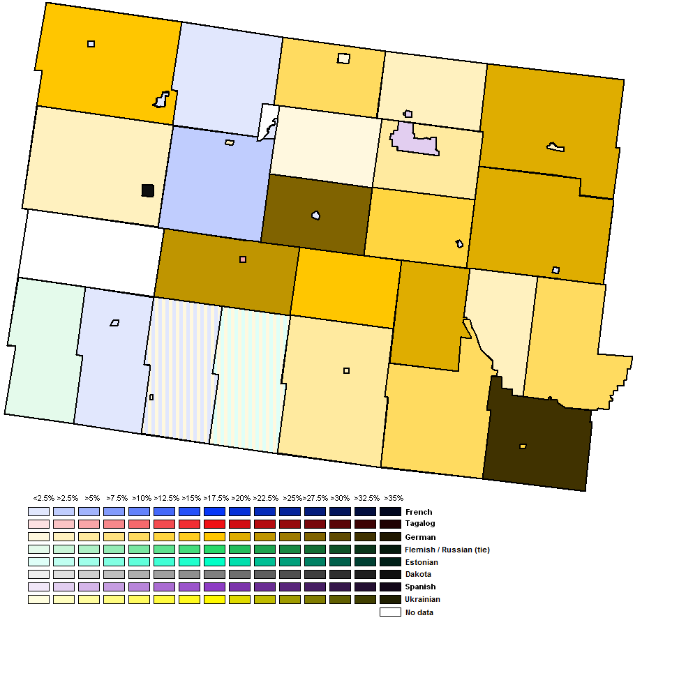
Leading non-English native language by Census Subdivision

Linguistically, English is by far the most common native language, with 86% of the riding having it as its mother tongue. The number two native language in the riding is German, at 4%, followed by Spanish (2%) and French (2%). German is the dominant second language in most parts of the riding, but they are concentrated mostly in the east. There are significant numbers of German native speakers (more than 20%) in the Rural Municipalities of Roblin, Glenwood, Cameron, North Cypress, South Cypress and Riverside. One other significant linguistic population lies in the Canupawakpa Dakota First Nation (Oak Lake), where 43% of residents are native Dakota speakers. One can assume that Dakota is widely spoken in Sioux Valley- the other Dakota Reserve, but no enumeration took place there. Also of note, Spanish is the second language of Brandon, although only 4% of the city are native Spanish speakers. Much of the southwestern corner of the riding lacks any linguistic diversity, which explains the light colours on the map. English is often the native language for 95-100% of the inhabitants in these areas. 


Candidates and expectations

Polls are suggesting that not only are the Liberals back to relevancy, but they are leading in this riding. Forum Research's most recent poll has the Liberals up 50-36 in this riding, an impressive lead indeed. So, what explains this? Well, the Liberal candidate in the riding brings some impressive name recognition. Their candidate is Rolf Dindsdale, who is the son of former Progressive Conservative MP Walter Dinsdale, who represented the area for 31 years. Rolf Dinsdale is a media executive with a colourful past, but the Dinsdale name runs deep in the city. Not only was his father a long time MP, but his grandfather was mayor of Brandon, and his brother is a two-time provincial Tory candidate. The Conservatives have a pretty strong candidate of their own in (now) former Athur-Virden MLA Larry Maguire. What's really hurting the Conservatives, however, is the ongoing Senate expenses scandal, among other things- that are really hurting the party. Another issue was with the nomination process with the Conservatives, which involved a candidate's nomination papers being rejected under dubious circumstances. With the riding supporting a Red Tory instead of a Reform or Canadian Alliance MP from 1997-2004 when surrounding ridings were electing Reform-Alliance Members of Parliament, it's not surprising to see the riding possibly going against the Conservatives, and electing a Liberal, son of a Tory MP. The NDP is running Labour Council president and Wawanesa resident Cory Szczepanski while the Greens are running greenhouse owner and Turtle Mountain resident David Neufeld.

If Forum Research is to be believed, the Liberals should take this riding, it what could be the only pick-up on by-election night. A Liberal win, would be the party would be sweeping the city of Brandon, where the Dinsdale name carries the most weight. Outside of Brandon will probably stay solidly conservative, especially the western part of the riding, which Maguire represented in the Manitoba Legislature. For the Liberals to win though, they have to break into the rural areas surrounding Brandon, as winning just the city will not be enough to win the riding. A Liberal pick up would be huge for the party, as it would be promoted as showing the public that they are the true alternative to the Conservatives, and would be a clear indicator that they are the number one party in the country at the moment.

Polls close in all four by-elections at 9:30 Eastern (8:30 Central).


Saturday, November 23, 2013

November 25 federal by-election profiles: Provencher

In the southeast corner of Manitoba lies the riding of Provencher, part three of my four part series in profiling Monday's federal by-election ridings. Provencher is a mostly rural riding that spans two different linguistic communities and is most notable for being the riding that sent Louis Riel to parliament. The riding is centred on the city of Steinbach, southeast of Winnipeg, but also includes a number of small communities, such as Ste. Anne and Lac du Bonnet. Provencher was vacated in July, when its scandal-ridden MP, (now) former Minister of Public Safety Vic Toews resigned.


History


Provencher was one of the original four ridings carved out of Manitoba when it became a province in 1870. By-elections were held in these four ridings in 1871 to elect the first members of parliament for the new province. Even in 1871, Provencher was located in the southeast corner of Manitoba. Although, at the time the eastern boundary of the province was at 96th meridian, further west than where it currently sits at, at about 95°10' W. Since 1871, Provencher has always at least consisted of the areas south of Steinbach, and east of the Red River. And almost from the very beginning, the riding has had a strong presence from the Franco-Manitoban and German Mennonite communities. To this day, both German and French are the native tongues of at least 10% of the riding respectively.

In 1871, the riding was dominated by French Metis settlers. At the time, the riding consisted of St. Boniface, today a largely Franco-Manitoban community in Winnipeg, as well as the Red River Valley south of Winnipeg and the rural area towards the east, including the Franco-Manitoban community of Ste. Anne. To this day, there is a Provencher Bridge and a Provencher Boulevard in St. Boniface. Over time, Mennonites from Eastern Europe and Germany began settling in the riding, especially in the Steinbach area, and a Mennonite Reserve was provided for them in what is now Hanover Municipality and Steinbach. The riding boundaries remained largely the same until 1914 (except for the eastern boundary of the province being formalized in 1891), when the northern boundary was shifted south to a straight line through Steinbach, separating Ste. Anne and St. Boniface from the rest of the riding. These areas were given to the new riding of Springfield. The riding also gained some territory around MacDonald rural municipality. The splitting of Steinbach only lasted until 1924, when the northern boundary was shifted northward slightly, while the western boundary was moved eastward closer to the Red River. In 1952, the riding expanded slightly westward, but no major changes occurred until 1966. In that year, the riding was expanded northward all the way to Berens River, more than half way up Lake Winnipeg. Also at the time, the western boundary was moved to the Red River south of Winnipeg. This shift brought Ste. Anne back to the riding, as well it added in Springfield Rural Municipality and Lac du Bonnet, but removed the Morris area for the first time in the riding's history. In 1976, the riding's northern boundary was pushed even further north, to the 57th parallel, while the western boundary was altered slightly. In 1987, the riding's boundaries were shifted back south, and the riding began to look similar to today. Morris rejoined the riding, as well as the Rhineland Rural Municipality, while Springfield was removed. The northern boundary was brought down to Powerview-Pine Falls close to where it is today. In 1996, most of Springfield rejoined the riding, while the northern boundary was moved south Pinawa. In 2003, the riding lost Rhineland, but gained the area between Pinawa and Poweverview-Pine Falls.

List of Provencher's MPs:

  1. Pierre Delorme, Cons. (1871-1872)
  2. G.-E. Cartier, Cons. (1872-1873)
  3. L.D. Riel, Independent (1873-1875)
  4. A.G.B. Bannatyne, Liberal (1875-1878)
  5. Jos. Dubuc, Cons. (1878-1879)
  6. A.A.C. Lariviere, Cons. (1889-1904)
  7. J.E. Cyr, Liberal (1904-1908)
  8. J.P. Molloy, Liberal (1908-1921)
  9. A.-L. Beaubien, Liberal (1921-1940)
  10. Rene Jutras, Liberal (1940-1957)
  11. W.H. Jorgenson, Prog. Cons. (1957-1968)
  12. M.G. Smerchanski, Liberal (1968-1972)
  13. A.J. Epp, Prog. Cons. (1972-1993)
  14. D. Iftody, Liberal (1993-2000)
  15. V. Toews, Canadian Alliance (2000-2003), Cons. (2003-2013)

The riding was mostly represented by Franco-Manitobans until 1957, including two Metis', Pierre Delorme and Louis Riel. (Although, Riel never sat in Parliament, and was expelled from the legislature in 1875 after being elected three times- one of those times was a by-election following him being unseated). In 1972, the riding elected its first Mennonite in Jake Epp. Toews is also a Mennonite.

Despite the riding electing an equal amount of Conservatives as Liberals in its history, the riding is a very safe Conservative riding. Toews has won comfortably since first being elected in 2000. Tories also dominated this riding between 1957 and 1993, losing only one election thanks to Trudeaumania. Tories also dominated the riding from 1871 to 1904 (losing only to Louis Riel and to the Liberals in 1875). Liberals held the riding uninterrupted from 1904 to 1957. The Chretien wave of 1993 helped the Liberals win the seat back in 1993, and a divided right wing kept the riding Liberal in 1997.

Today, at nearly 100,000 people, Provencher is the most populated and also fastest growing riding in Manitoba. This has meant that the federal riding boundary commission had to make the riding smaller, when it released its final report earlier this year. The report has the northern boundary of the riding shifting southward once again, leaving the communities of Pinawa, Lac du Bonnet and Powerview-Pine Falls to join the new riding of Selkirk—Interlake—Eastman. The western boundary will also change, with both the Town and Rural Municipality of Morris being removed for the riding once again, and given to neighbouring Portage—Lisgar. Also, all of Springfield will be united in Provencher, instead of the current set up where the area north of Garven Road is in a different riding.


Political geography


Vic Toews has been able to win the riding with massive majorities since 2004, including winning 71% of the vote in 2011. However, before the Conservatives united in 2003, the riding featured close races between the Reform Party/Canadian Alliance and the Liberals in 1993, 1997 and to a lesser extent in 2000. It is in these elections, that the linguistic polarity (Mennonite Germans vs. Franco-Manitobans) can be seen best. During these elections it was the Franco-Manitobans that backed Liberal candidate David Iftody, while Mennonite German areas voted Reform/Canadian Alliance. The rest of the riding (mostly in the east) was the true battleground. Since 2004 however, the riding has become solid blue. Both in 2008 and 2011, the Liberals won not one single poll. You can still see the French areas of the riding on those maps however, as those areas are still less Conservative (lighter blue) than the rest of the riding. Meanwhile, the darkest blue areas are the German Mennonite regions of the riding, where it was not uncommon for Vic Toews to break 80% in any given poll. 

Between 1988 and 2006, the top two parties in the riding have been the Liberals and the Tories (or Reform/Canadian Alliance). However, in both the 2008 and 2011 elections, the NDP has become the 2nd party of the riding. Between 1988 and 2006, the NDP was stuck in the single digits before winning 14% in 2008 and 18% in 2011. The Liberals finished third in both elections, including 7% in 2011, their worst showing since 1930.

Both the 2008 and 2011 maps are very similar. The Tories won all but one poll in both elections, which was won by the NDP each time. That one poll is the Roseau River Indian Reserve in the south of the riding. The reserve consists of two parts, which is why it looks like the NDP actually won two polls.

In both elections, the most Conservative areas were the German Mennonite regions of Morris in the west, and Hanover and Steinbach in the central-west part of the riding. Outside the Roseau River Indian Reserve, the Tories were weakest in the Franco-Manitoban belt, that beings in the southwest part of the riding, goes between Morris and Hanover, and circles around Hanover ending on the east side of it. This belt includes the rural municipalities of Montcalm, De Salaberry, Ritchot, Tache and Ste. Anne, as well as the towns of Ste. Anne and St-Pierre-Jolys. In 2008, the Liberals did the best in this region, coming within one vote of winning one of the Ste. Anne polls. In 2011, much of this support shifted to the NDP. It was not just Francophones in Quebec who were brought in on the “Orange Wave”. In 2008, the strongest NDP areas were not in the Franco-Manitoban belt, but were rather in the northern part of the riding, an area with fewer Germans or French.

2011 results by polling division
In 2011, the strongest Conservative poll was #127, which covers the southern half of the community of Blumenort in Hanover Rural Municipality. It also contains the community of Clear Springs in Hanover, and some of Ste. Anne Rural Municipality. The Conservatives won an astounding 92% in that poll, as well as the neighbouring poll #128 covering the other half of Blumenort. Not surprisingly, the only poll the NDP won (poll #91) was their best poll, where they won 58%. Again, this poll covers the Roseau River Reserve. The next best poll for the NDP was 36% in poll #71 in Ste. Anne. 

2008 results by polling division

In 2008, poll #127 was also the strongest poll for the Tories. Vic Toews picked up 87% of the vote there. The NDP's best poll was again #91 again, where they won 44%. The next highest was #25 covering the community of Prawda on the Trans-Canada Highway in Reynolds Rural Municipality, where they won 35%. The Liberal's best poll was #71, in Ste. Anne Rural Municipality, where the party won 34% of the vote, losing by one single vote. This poll covers the rural area surrounding the Town of Ste. Anne, including the community of La Coulee.

2008-2011 Two-party swing

Provencher two-party swing (Conservatives vs. NDP) from 2008 to 2011


The 2008 and 2011 elections produced similar results with Toews winning 65% and 71% respectively, and the NDP winning 14% and 18% respectively. Both parties saw a modest increase in their vote share, resulting in a small two-party swing of 0.9% from the NDP to the Conservatives. Both parties gained mostly from the collapse of the Liberals, and to a lesser extent the Greens, as well as the right wing Christian Heritage Party, which actually finished 2nd place in a number of polls. Blue areas on my swing map basically show polls were the Tories benefited the most from this vote collapse, while orange areas show where the NDP benefited from the collapse. In the Franco-Manitoban belt, the NDP was the party that benefited the most from the Liberal collapse in their traditional territory. Albeit, the swing to the NDP there was very small, indicated by the very light shades of orange on the map. Much of the rest of the riding swung to the Tories. Not many areas swung heavily to either party.


Demographics


Provencher is a typical rural riding, in that it has a high percentage of Whites, at 85%. Most of the rest, 12% is of Aboriginal descent. Most Aboriginals in the riding are in fact Metis, a remnant of the riding's history. 80% of the riding is Christian. The National Household Survey's “Other Christian” category is the largest Christian group, at 36%. Many of these people are understandably Mennonites. 24% are Catholics, and the United Church is the largest Protestant denomination at 6%. 20% of the riding is non religious. The median income in the riding is $29,000 and the average income is $36,000. This is typical for the province. Over one third of the riding identifies as ethnically German. There are also large numbers of people who identified as ethnically French, English, Ukrainian, Scottish and Russian.

Leading non-English native language by Census Subdivision


Linguistically, two thirds of residents have English as their native language. 17% are native German speakers and 10% are native French speakers. Native German speakers are concentrated in the former Mennonite Reserves, like in Hanover, Steinbach and Morris. La Broquerie, an historically French municipality next to Hanover also has more native German speakers than French. Native French speakers are concentrated in the Franco-Manitoba belt, which I mentioned earlier as running from Montcalm Rural Municipality in the south, down the Red River Valley, and wrapping around Hanover to include Ste. Anne. One town, Saint-Pierre-Jolys actually has more native French speakers than English. It is the only municipality in the riding where English isn't the number one native language. There are also French concentrations in the north end of the riding, mostly in Alexander Rural Municipality.


Candidates


Due to the fact that Provencher is such a safe seat, the race there has become the least interesting of the four elections. And this fact is not just based on voting history but is also confirmed with polling data. But perhaps the Conservatives should be a little bit concerned, as a Forum Research poll conducted on November 22 shows the Tories with just an 11 point lead (48-37) over the Liberals there. Forum had the Tories ahead by 21 points just a week before. If momentum continues, the Liberals could even pick this seat up! Right now, Provencher is actually the only one of the four ridings where the Liberals are not ahead. Anything is possible though, with Justin Trudeaumania sweeping the country, the Tories in hot water over Senate scandals, and their local candidate being a no show for debates.

The Conservative front runner is Ted Falk, who is a Mennonite from Steinbach, and a businessman. He is also the former President of the Steinbach Credit Union. According to polls, Falk's main opponent is Terry Hayward of the Liberal Party. Hayward is a retired public servant from Springfield, and was the former President of the Beausejour chapter of something called “Canadian Parents for French”. The NDP is running a Francophone in Natalie Courcelles Beaudry, also a public servant. The Greens are running Janine Gibson, a past president of Canadian Organic Growers. She lives near Steinbach.

If the Liberals are only behind by 11 points in this riding, that means they will likely gain back much of the Franco-Manitoban belt that has slipped away from them in recent elections. It, of course, doesn't hurt that their candidate was President of a French organization. The NDP may actually be running a Francophone candidate, but it appears she isn't making any inroads in the riding. She may prevent the Liberals from winning enough of the Francophone vote to win the seat. But the Liberals need more than just the Francophone areas to win; they'll need some of the rural eastern and northern areas to win. Just placing second in Provencher would be good news for the Liberals, though who have finished third for the last two elections. A win would be a sign that the Liberals are back on top across the country.